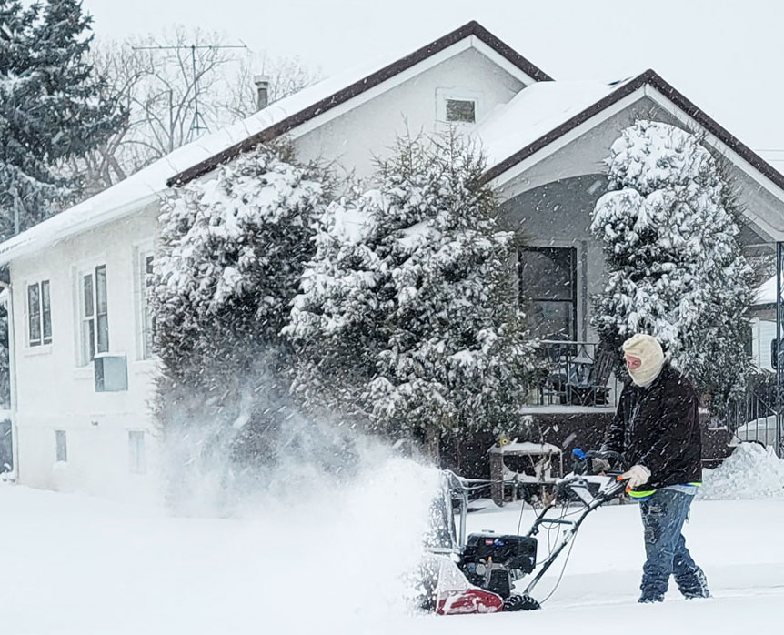
Schools across the area, the Lincoln County courthouse and most businesses closed tight and most people stayed inside Wednesday as more than a foot of snow fell in the North Platte area.
Schools will remain closed Thursday.
The snowstorm arrived around 2 a.m. Wednesday. Before dawn, I-80 and U.S. 30 were closed at Kearney and across western Nebraska.
——————-
Top Photo: Kevin Petska blows snow off his neighbor’s sidewalk around 10:30 a.m. Wednesday near E and Cottonwood in North Platte.
——————-
In addition to 7-8 inches that fell overnight, another 7 inches fell in some places on Wednesday, with northerly winds that reached 30 mph in the afternoon, the National Weather Service in North Platte said.
By 6:30 p.m., the National Weather Service at Lee Bird Field recorded 12.3″ of snow, a new single-day record during January at North Platte, and the third-highest single-day snowfall since 1875.
A Bulletin staffer measured 15 inches near Lake Maloney. Another staffer recorded nearly 14 inches just south of Maxwell.

North Platte officials issued a snow emergency at 5 p.m. Tuesday. City crews started working during the night and continued to stay on the streets, keeping major routes open for emergency vehicles and vital traffic.
No overnight parking will be allowed along the storm routes nor in the core downtown area through Thursday night, city officials said.
The storm is cutting a wide path from southwest to northeast Nebraska, falling over most of the state. North Platte is in the middle of the path, but northern Custer County was expected to receive the heaviest amount, the weather service said.
Travel is hazardous and is not recommended. If you have travel plans, be prepared to alter or
delay them. Know before you go. Road conditions are updated at 511Nebraska.gov.
If you have to travel, pack a kit of emergency supplies, including water, winter wear, blankets, nutrition bars and other items you might need if you get stranded. If stranded or in need of assistance, call *55 or 800-525-5555 to reach the Nebraska State Patrol Highway Helpline.
Looking ahead, temperatures are forecast to remain below freezing at least through Sunday, so snow will remain on the ground at least for several days, the weather service said.
(This report was updated at 7 p.m. CST.)
Emergency snow routes
RODEO ROAD – Jeffers west to city limits
EAST 12TH – Jeffers east to city limits
WEST 9TH – Jeffers to West city limits
EAST 8TH – Jeffers to East city limits
WEST 14TH – Buffalo Bill Avenue to Adams Avenue
WEST 16TH – Webster Avenue to Buffalo Bill Avenue
WEST 18TH – Buffalo Bill Avenue to Sheridan Avenue
WEST 19TH – Sheridan Avenue to Adams Avenue
ROOSEVELT AVENUE – 8th Street to 14th Street
BRYAN AVENUE, NORTH – 16th Street to Railroad Street
POPLAR STREET – 4th Street to 12th Street
POPLAR STREET – Francis Street to Philip Avenue
JEFFERS STREET – North city limits to South city limits
ADAMS AVENUE – 9th Street to 19th Street
SHERIDAN AVENUE – Rodeo Road to 19th Street
DODGE AVENUE – 9th Street to North city limits
DEWEY STREET – South city limits through S-curve to Jeffers
WILLOW STREET – Leota Street to Rodeo Road
WILLOW STREET – Walker Road to State Farm Road
FRONT STREET – West city limits to Poplar Street
4TH STREET – Pacific Street to East city limits
2ND STREET – Buffalo Bill Avenue to West city limits
“A” STREET – Willow Street to West city limits
“B” STREET – Sherman Avenue to Bicentennial Avenue
“E” STREET – Bryan Avenue to Dixie Avenue
PHILIP AVENUE – Lakeview Blvd to Newberry Access
FRANCIS STREET – McDonald Road to 300 feet east of Poplar Street
LEOTA STREET – Oak Street to East city limits McDonald Road to Bare Avenue
EUGENE AVENUE – Highway 83 west to city limits
WALKER ROAD – Highway 83 west to city limits
WALKER ROAD – Newberry Road access west to dead-end
HALLIGAN DRIVE – From U.S. Hwy 83 east to Newberry Access
BICENTENNIAL AVENUE – Highway 30 (4th St.) south to Philip Avenue
INDUSTRIAL AVENUE – Philip Avenue to Prospect Drive
PROSPECT DRIVE – Industrial Avenue to Philip Avenue
WELCH AVENUE – Philip Avenue to 4th St.
BRYAN AVENUE, SOUTH – Front Street to Philip Avenue
SILBER AVENUE – Philip Avenue to 4th St.
COTTONWOOD STREET – 4th Street to Wal-Mart entrance
OAK STREET – Leota Street to Front Street
JEFFERSON AVENUE – “A” Street to Front Street
McDONALD ROAD – “A” Street to Leota Street
SHERMAN AVENUE – “B” Street to Front Street
CARR AVENUE – Leota Street to Front Street
MILLS AVENUE – 4th Street to Front Street
BUFFALO BILL AVENUE – North city limits to Leota Street
PACIFIC STREET – 4th to Front Street
BARE AVENUE – Leota to Front Street
LAKEVIEW BLVD – “A” Street to Philip Avenue
NEWBERRY ACCESS – North city limits to South city limits
STATE FARM ROAD – East city limits to West city limits
SOUTH PARKWAY – State Farm Road north to Fremont Slough
SUNRISE DRIVE – South Parkway to Hwy 83
ELDER AVENUE – 2nd Street to ‘E’ Street
TABOR AVENUE – Philip Ave. to a point approx 300 feet south of Francis.
© 2023 The North Platte Bulletin. All rights reserved.
The National Weather Service is now predicting 11-17 inches of snow for our area.
As of mid-afternoon Tuesday, there is a 10% chance of more than 12 inches, the weather service said.
Another snow event where NPPD Chief wont hold his patrol accountable for ticketing in snow routes. Heck there are still vehicles that havent moved since before the last snow.
Record breaking snowfall and yet the city won’t even do the bare minimum to help those of us on side streets